University of Minnesota
http://www.umn.edu/
612-625-5000
http://www.umn.edu/
612-625-5000
Minnesota Biodiversity Atlas
Bell Museum
Dataset: MIN-Fungi
Search Criteria: United State; excluding cultivated/captive occurrences
1
Page 1, records 1-10 of 10
Bell Museum fungi | |
 MIN:Fungi |  Ustilago striaeformis Johnston{?} 14122[1220106]Clinton, G.P. 911896-05-00 United State, Illinois, Urbana |
MIN:Fungi |  Puccinia anomala Rostr. 308846[1234135]Carr, W.P. 2631911-03-26 United State, Texas |
MIN:Fungi |  613154[1236322]Holway, E.W.D. s.n.1901-09-22 United State, Iowa |
MIN:Fungi |  Puccinia effusa Dietel & Holw. 457752[1236472]Tracy, Joseph P. 181831948-09-05 United State, California, Humboldt, 2 miles east of Grove's Prairie; Trinity Summit., 1524m |
MIN:Fungi | 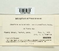 Puccinia extensicola var. oenatherae (Mont.) Arthur 494951[1236788]Seymour, A.B. s.n.1908-06-04 United State, Massachusetts, Cherry Brook; Weston |
MIN:Fungi | 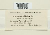 [1236842]Seymour, A.B. 601882-10-24 United State, Illinois |
MIN:Fungi | 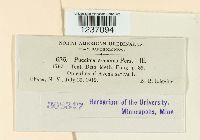 Puccinia graminis Pers. 308347[1237094]Higgins, B.B. 6361912-07-29 United State, New York |
MIN:Fungi | 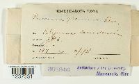 Puccinia graminis Pers. 308946[1237331]Brenckle, J.F. 197 United State, North Dakota |
MIN:Fungi |  313505[1238496]Long, W.H. 6181 United State, Texas |
MIN:Fungi |  Puccinia minussensis Thüm. 317591[1239804]Brenckle, J.F. 2317 United State, North Dakota |
1
Page 1, records 1-10 of 10
Google Map
Google Maps is a web mapping service provided by Google that features a map that users can pan (by dragging the mouse) and zoom (by using the mouse wheel). Collection points are displayed as colored markers that when clicked on, displays the full information for that collection. When multiple species are queried (separated by semi-colons), different colored markers denote each individual species.